




Loading

Industry

Government & Smart Cities

Turning the built environment into a measured, queryable 3D model. AECA gives local authorities and government agencies the spatial base layer that planning, simulation and IoT intelligence are built on.

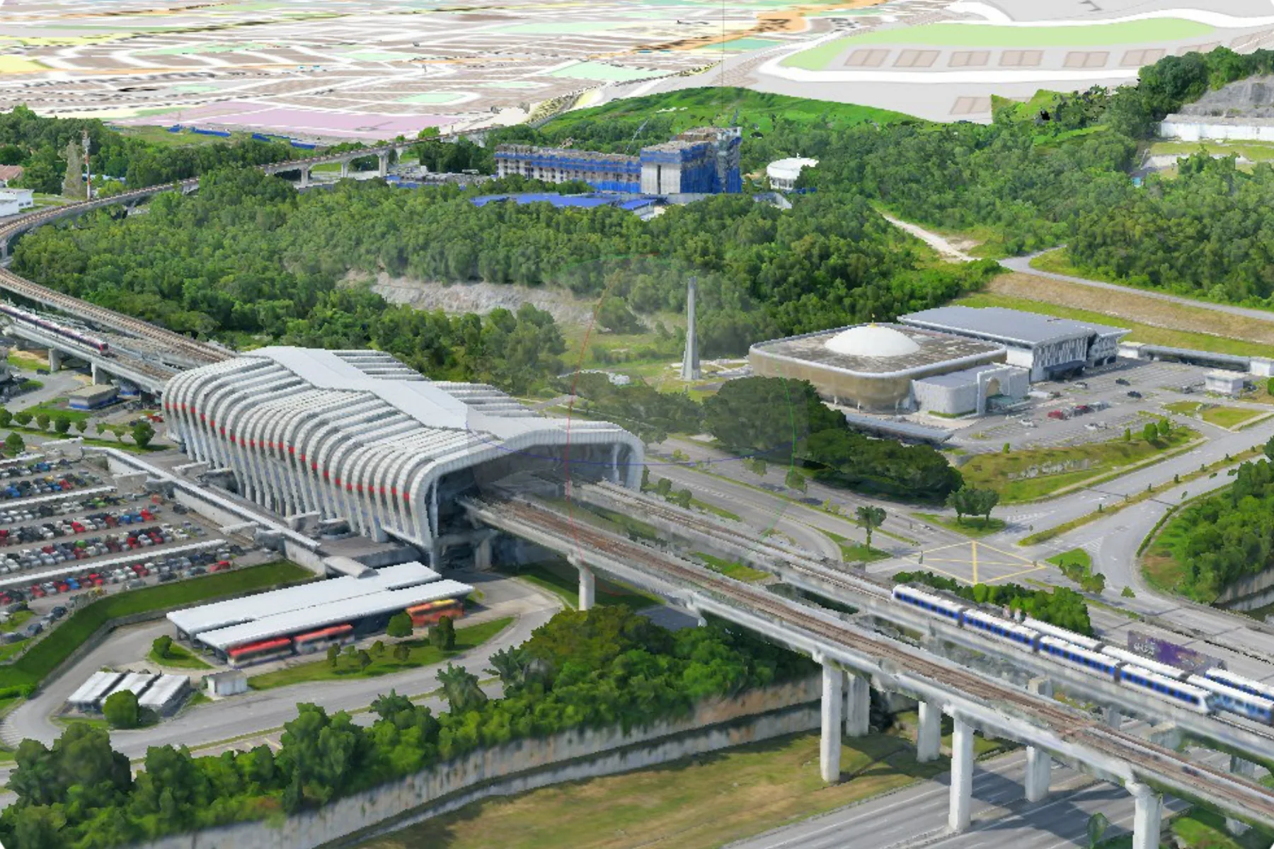
Textured 3D city model of a Malaysian transit interchange, with the modelled station roof, elevated rail viaduct and car parks below a flat cadastral map layer of the same district
Largest twin
9.5 sq km in three hours
Model types
3D mesh, Gaussian Splats, point cloud
Access
In the browser, nothing to install
Integrations
Planning, GIS and asset systems

Capabilities in this sector

The named services AECA delivers here. Each one answers a problem set out below.

High-Fidelity 3D Urban Reality Modeling

Planning decisions get made against 2D drawings that cannot show massing, shading or access.

Digital Twin for Simulation & Planning

New roads, new buildings and flood schemes get approved before anyone can see what they do to the place.

Centralised Smart Infrastructure Ecosystems

Engineering, facilities and planning each hold part of the truth, in systems that do not talk.

Industry challenges

Authorities run cities from fragmented 2D drawings and disconnected databases. The harder problem underneath is the sharing: data that never crosses between agencies cannot become the reference a decision is defended on.

Fragmented and siloed asset information

Engineering teams, facility managers and planners work out of isolated databases and static spreadsheets, which delays decisions and repeats site inspections.

No real-time context for smart city operations

Static planning maps cannot show dynamic development, environmental stress or asset condition, which is exactly what smart city operations and simulation need.

Design conflicts and costly clash redos

Planning retrofits from outdated architectural records produces layout clashes during construction, and the cost lands as rework and delay.

Prohibitive data acquisition costs

Traditional survey over a municipal area takes months and disrupts public activity, so the base data is refreshed rarely and the plan is written against a city that has moved on.

AECA's solutions

A digital twin is only useful if it is accurate, current and reachable by everyone who needs it. AECA works on this through the Malaysia Smart City Alliance, alongside Urbanice Malaysia and PLANMalaysia.

High-fidelity 3D urban reality modelling

Large-scale 3D mesh models of metropolitan zones and infrastructure corridors, captured from the air and the ground, for development simulation at true scale.

Digital twin for simulation and planning

Proposed roads, buildings and drainage placed into the model at true position, so massing, access and runoff are assessed against measured reality before commitment.

Web-based GIS and open platform integration

Cross-platform web viewers open the twin anywhere without a local install, integrating with ArcGIS Urban, open-source web GIS pipelines and enterprise asset software.

Benefits

What changes for an authority once the city is a model rather than a drawer of drawings.

  • One source of truth Planning, engineering and operations argue from the same measured model, which removes the reconciliation work preceding every cross-department decision.
  • Decisions before commitment Schemes are tested in the model at true scale, so clashes, access problems and massing objections surface at design stage instead of on site.
  • Reachable without specialist software A browser-based twin puts the same data in front of a councillor, a contractor and a field crew, none of whom need a GIS licence.
  • A base layer that compounds The model is captured once and revisited each cycle rather than re-surveyed. Where integration across systems has been achieved it has delivered up to 30% efficiency gains in township management.

Case studies

How the data has translated into decisions for public sector teams.

Kuala Lumpur City Centre digital twin

The challenge
Development proposals across a dense city centre are assessed against 2D plans and site photographs, so massing, shading and access impacts are argued rather than seen.
The deployment
A Quantum Systems Trinity Pro carrying the Oblique D2M five-lens camera covered roughly 9.5 sq km in three hours of flight time.
The result
A textured 3D model schemes can be placed into at true scale. The same imagery was later reprocessed in Skyline PhotoMesh as a Gaussian Splats model with no new flights.


A decade of Selangor state programmes

The challenge
State agencies hold road, parking, waste and asset duties, but the spatial records behind them are collected piecemeal by different teams to different standards.
The deployment
Ten years of delivery with the Selangor State government across JKR road asset management, the MARRIS programme, smart parking, road condition and waste management.
The result
Geospatial capture, analysis and reporting commissioned as normal practice rather than as one-off studies.

As-built record for facility operations

The challenge
Drawings no longer match the building after years of modification, so every upgrade begins with a rediscovery exercise and carries clash risk.
The deployment
The facility is scanned and the point cloud converted to structured geometry, with equipment and services tagged in place.
The result
A measured as-built model that maintenance and design teams work from directly, instead of drawings of a building that no longer exists.

Turn insight into action

Solve your next operational challenge.

Tell us what you need to measure, monitor or manage.
