Discover how LiDAR mobile mapping is paving the way for digital infrastructure, enabling better infrastructure management through accurate corridor mapping, digital twins, and scalable asset monitoring for roads, rail, and utilities
Malaysia’s infrastructure landscape is expanding rapidly. From highways connecting growing regional cities to MRT and LRT lines transforming urban mobility, transport and utility networks across the country are evolving at an unprecedented pace.
As these networks grow, the ability to capture, monitor, and manage infrastructure data at scale is becoming increasingly important. This is where LiDAR mobile mapping for infrastructure management is emerging as a powerful enabler of digital infrastructure.
Table of Contents
- Infrastructure expansion and the need for digital infrastructure intelligence
- The shift from project surveys to continuous infrastructure intelligence
- What is LiDAR mobile mapping?
- Direct georeferencing: The backbone of reliable infrastructure data
- Multi-platform mapping for complex infrastructure environments
- Sensor fusion: Turning point clouds into infrastructure intelligence
- Mapping infrastructure in GNSS-challenging environments
- Balancing efficiency, complexity, and cost in infrastructure mapping
- Technology in action: Case study
- Conclusion
Infrastructure expansion and the need for digital infrastructure intelligence
Across Southeast Asia — and particularly in Malaysia’s rapidly developing infrastructure landscape — transportation and utility networks are expanding at an unprecedented pace.
From the Klang Valley’s expanding urban rail networks to highways linking growing regional cities, transport and utility corridors are evolving rapidly. New infrastructure is being built, while existing networks must be continuously monitored and maintained across dense urban districts, industrial zones, and smaller towns.
Highways continue to extend outward from major cities such as Kuala Lumpur, Johor Bahru, and Penang. Rail systems are growing through MRT (Mass Rapid Transit), LRT (Light Rail Transit), and commuter rail networks, while utilities multiply beneath increasingly dense urban grids. Ports, airports, and logistics hubs are also being modernised to support regional trade and manufacturing.
According to the latest available national infrastructure statistics, Malaysia’s transport network spans hundreds of thousands of kilometres of roads and a rapidly expanding system of highways and urban rail lines.
But building infrastructure is only part of the story.

The real complexity lies in managing, maintaining, and monitoring infrastructure assets throughout their lifecycle.
Government agencies, transport authorities, and utility operators — including Keretapi Tanah Melayu (KTM), Prasarana Malaysia, Tenaga Nasional Berhad (TNB), Telekom Malaysia, and many local authorities (PBTs) — require accurate spatial data to support planning, operations, and long-term maintenance.
This growing need for large-scale infrastructure visibility is one of the key drivers behind the adoption of LiDAR mobile mapping technologies.
By combining high-density LiDAR scanning, precise positioning systems, and imaging technologies, mobile mapping systems enable organizations to capture detailed spatial data across large infrastructure networks quickly and efficiently.
The shift from project surveys to continuous infrastructure intelligence
Traditionally, surveys were conducted for individual projects such as road expansions, rail construction, or utility installations. Once the project was completed, the collected data was typically archived.
However, modern infrastructure environments require a more continuous approach.
Asset owners today increasingly need:
- Continuous monitoring
- Digital twins of infrastructure networks
- Real-time asset visibility
- Predictive maintenance capabilities
As Malaysia’s infrastructure networks expand across both dense urban environments and rural communities, infrastructure operators need scalable ways to monitor thousands of kilometres of roads, rail corridors, and utility networks.
Mobile LiDAR mapping systems help address this challenge by enabling fast, accurate, and scalable data collection across large geographic areas.

What is LiDAR mobile mapping?
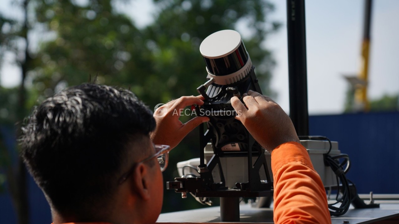
LiDAR mobile mapping combines laser scanning, GNSS positioning, and inertial navigation systems to capture accurate 3D spatial data while moving through an environment using vehicles, drones, or handheld platforms.
High-quality systems can achieve centimetre-level accuracy, making them suitable for applications such as:
- Road corridor mapping
- Rail clearance analysis
- Infrastructure asset inventories
In Malaysia, these capabilities are relevant across infrastructure that spans both scale and geography — from urban rail networks like MRT and LRT and national rail projects such as the East Coast Rail Link, to the country’s major highway corridors, including the North–South Expressway, LPT, Karak Highway, and Pan Borneo Highway, along with urban expressways such as DUKE, SUKE, DASH, SPRINT, and LDP that support everyday connectivity.

Direct georeferencing: The backbone of reliable infrastructure data
A key innovation in modern mobile mapping is direct georeferencing, which integrates:
- Survey-grade GNSS
- High-precision inertial measurement units (IMU)
- Trajectory estimation algorithms
These systems generate accurate spatial positioning during data capture without heavy reliance on ground control points.
This is especially important in real infrastructure environments such as elevated MRT and LRT corridors in Kuala Lumpur, highway flyovers, or railway tunnels along KTM routes, where satellite signals can be degraded by urban structures, tunnels, or dense vegetation.
High-grade inertial navigation systems maintain stable trajectory estimation during temporary GNSS interruptions, ensuring reliable spatial data collection across complex infrastructure environments.

Multi-platform mapping for complex infrastructure environments
Infrastructure corridors rarely exist in a single environment. A mapping project may begin in the centre of Kuala Lumpur and extend outward along highways, rail corridors, and utility routes into smaller towns and kampung communities.
Typical infrastructure mapping may involve:
- Highway corridors
- Rail infrastructure
- Urban pedestrian zones
- Bridges and elevated structures
- Industrial facilities or confined spaces
Platforms such as the SCANFLY EVO allow the same sensor architecture to be used across these deployment modes, enabling flexible infrastructure data collection while maintaining consistent datasets.

Sensor fusion: Turning point clouds into infrastructure intelligence
LiDAR sensors generate dense 3D point clouds that represent the physical environment in great detail.
However, infrastructure management requires more than geometry alone. Modern mobile mapping systems therefore combine several sensors simultaneously, including:
- LiDAR scanners
- High-resolution panoramic cameras
- RTK GNSS receivers
- Inertial measurement units
By synchronising these data streams, mapping systems produce both spatial geometry and visual context, enabling applications such as:
- Pavement condition monitoring
- Road signage inventories
- Asset identification
- Vegetation encroachment analysis
- Utility corridor management
For highway operators and city authorities in Malaysia and across Southeast Asia, these datasets provide a powerful foundation for managing complex infrastructure networks.

Mapping infrastructure in GNSS-challenging environments
Many infrastructure environments pose challenges for satellite positioning, including:
- MRT and LRT systems
- Road tunnels
- Underpasses
- Dense urban districts
To overcome these limitations, mobile mapping systems incorporate Simultaneous Localization and Mapping (SLAM) algorithms.
SLAM analyses geometric features in LiDAR data to estimate position and orientation when GNSS signals are unavailable. This improves mapping reliability in mixed environments such as rail corridors that transition between dense urban areas and rural communities.
Balancing efficiency, complexity, and cost in infrastructure mapping
When infrastructure organisations explore mobile LiDAR technologies, discussions often centre around two practical considerations: operational complexity and cost efficiency.
For teams accustomed to conventional survey workflows, adopting new technology can initially appear complex. In practice, however, modern mobile mapping systems often simplify infrastructure data collection by reducing manual field processes and consolidating multiple data collection tasks into a single operation.
Operational simplicity in modern mobile mapping systems
Infrastructure inspections have traditionally relied on manual field documentation. Survey teams capture photographs, record observations on site, and mark locations using handheld GPS devices before compiling reports.
While familiar, this approach often involves repeated site visits, fragmented datasets collected at different times, and significant effort to consolidate observations into usable reports.
Mobile LiDAR mapping changes this workflow.
Instead of documenting infrastructure point by point, survey teams can capture a complete digital record of corridors in a single pass.
In many operational deployments, mobile LiDAR mapping has demonstrated the ability to collect infrastructure data 50–70% faster than conventional survey methods, significantly reducing time spent in the field while producing richer datasets.

When evaluating infrastructure mapping technologies, it is important to consider the full operational picture.
Manual survey methods may appear inexpensive initially, but across large infrastructure networks they often involve hidden costs such as repeated site visits, traffic management arrangements, extended project timelines, and labour-intensive reporting processes.
Mobile LiDAR mapping addresses many of these inefficiencies by capturing comprehensive datasets in a single survey operation.
Industry deployments indicate that mobile mapping technologies can deliver 10–20% operational cost savings, largely due to reduced field time, streamlined processing workflows, and the ability to reuse datasets for multiple infrastructure applications.
Technology in Action
Read our case study on how Malaysian rail operator KTMB deployed LiDAR-based railway corridor mapping by AECA Solutions to improve rail safety, vegetation management, and right-of-way monitoring.
By combining accurate spatial data with clear visual information, AECA Solutions helped KTMB move toward a more data-driven approach to vegetation and right-of-way monitoring.
As railway networks in Malaysia continue to grow, such digital inspection methods will play an increasingly important role in supporting safe, reliable, and well-maintained rail services.

Conclusion
For rapidly developing countries such as Malaysia — where transport networks, utilities, and urban infrastructure continue to expand — scalable mapping technologies will play an increasingly important role in digital infrastructure management.
From highways and rail corridors to power and telecom networks, LiDAR mobile mapping enables infrastructure owners to capture, process, and analyse spatial data more efficiently.

These digital datasets form the foundation for smarter infrastructure planning, improved maintenance strategies, and the development of large-scale digital twins.
Technologies such as the SCANFLY EVO and PRO platforms demonstrate how compact survey-grade systems can support large-scale digitisation across cities, transport networks, and utility grids.
The future of infrastructure will not only be built in concrete and steel.
It will also be built in point clouds, trajectories, and intelligent spatial data layers — captured efficiently, processed reliably, and deployed at scale.
And LiDAR mobile mapping sits at the centre of that transformation.
AECA Solutions Sdn. Bhd. is a leading provider of LiDAR mobile mapping services and official reseller for SCANFLY in Malaysia. We are excited to explore the possibilities of LiDAR mobile mapping to support national growth and digital infrastructure. Let’s connect at info@aeca-solutions.com or DM us.