Discover how Keretapi Tanah Melayu Berhad (KTMB) uses LiDAR-based railway corridor mapping to improve rail safety, vegetation management, and right-of-way monitoring in Malaysia.
Why railway corridor safety matters
Railway infrastructure forms the backbone of national mobility, supporting economic growth, urban connectivity, and daily commuting. As railway networks expand, maintaining safe clearances along rail corridors becomes increasingly complex. Vegetation regrowth, encroachments, and changing environmental conditions pose continuous challenges for rail operators.
In Malaysia, Keretapi Tanah Melayu Berhad (KTMB) is addressing these challenges by adopting LiDAR-based railway corridor mapping, replacing traditional manual inspections with a faster, safer, and data-driven approach.
Challenges of traditional railway corridor inspections
Conventional corridor inspections rely heavily on manual processes. Inspection teams walk along tracks, capture photographs, and prepare reports based on visual observations.
While effective for basic assessments, manual inspections present several limitations:
- High exposure of personnel to active railway environments
- Inconsistent results due to human subjectivity
- Difficulty in comparing corridor conditions over time
- Time-consuming surveys over long rail stretches
These challenges highlighted the need for a more consistent and scalable inspection method.
KTMB’s LiDAR-based corridor mapping initiative
To improve how this process is carried out, Malaysian rail operator KTM Berhad initiated a LiDAR-based railway corridor mapping project along a 32 km section between Rawang and Kuala Lumpur. The aim was to obtain a clearer, more accurate view of vegetation conditions and right-of-way status, using digital data rather than manual observation alone.
AECA Solutions Sdn. Bhd. collaborated with VStream Revolution Sdn Bhd to carry out the work using a mobile mapping approach. This approach is adapted to suit real-world railway operations and access conditions.
A Practical mobile LiDAR solution for rail corridors
By using LiDAR-based mapping, KTMB was able to move toward a more consistent and repeatable inspection method, while also reducing the amount of time personnel needed to spend on the track.

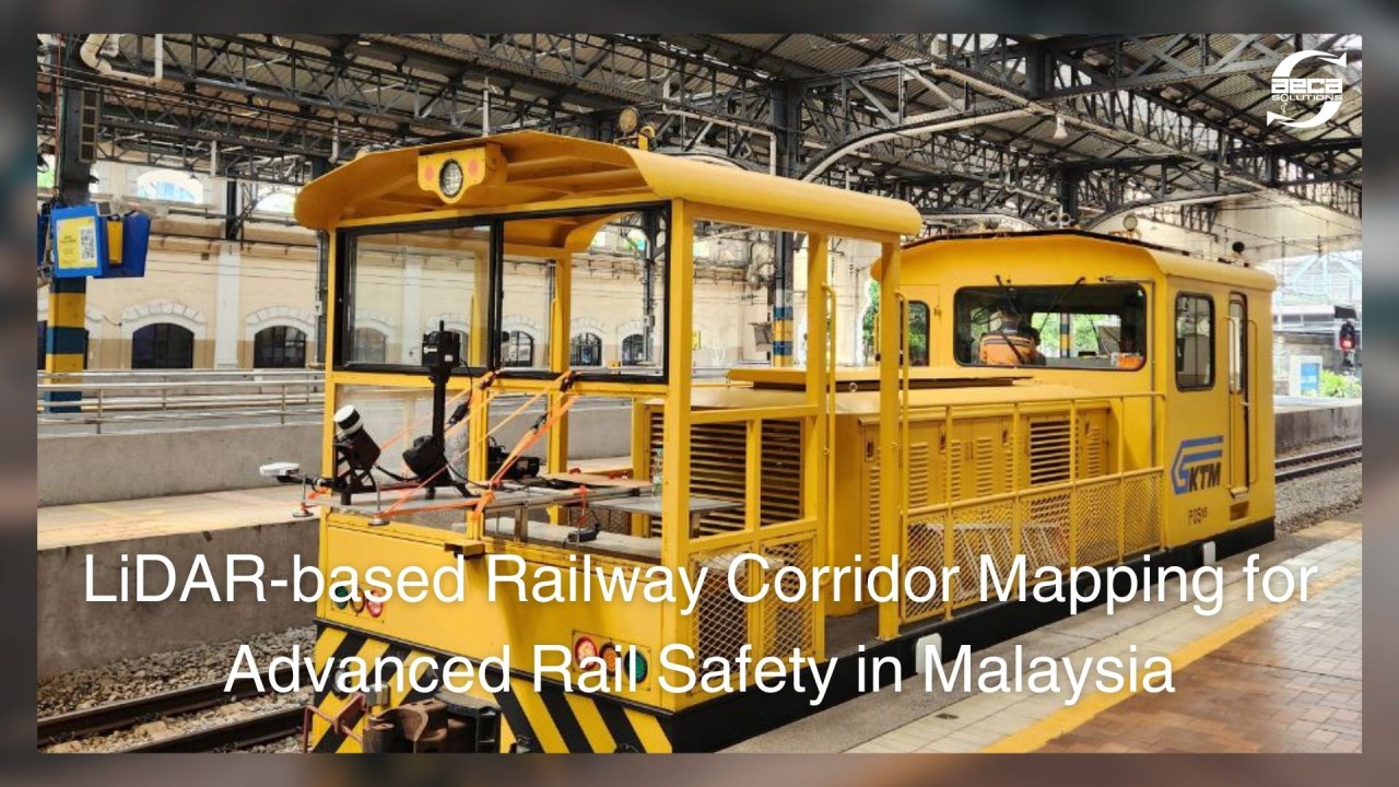
The project deployed a mobile mapping system mounted on a railway maintenance trolley. This setup allowed data to be collected directly along the track alignment during approved maintenance windows, without affecting normal train operations.
The system combined:
- High-density LiDAR scanning for precise 3D corridor data
- 360° panoramic imagery for visual reference
- Integrated georeferencing for consistent spatial accuracy
This configuration delivered a complete digital representation of the railway environment in a single survey run.

This approach provided a complete picture of the track environment, including vegetation, overhead elements, and nearby structures, all recorded with high spatial accuracy.
Beyond immediate corridor visibility, the same dataset can support a range of analytical use cases, such as assessing overhead line conditions, identifying potential sagging, and mapping the precise location and condition of rail assets along the corridor.
While not all of these analyses were required for this specific exercise, they form part of a broader rail maintenance toolkit enabled by high-resolution LiDAR-based mapping.

Working within railway operating constraints
Survey work on railway infrastructure must follow strict safety and operational rules.
One key consideration was ensuring that all equipment remained stable and secure while the trolley was in motion. AECA addressed this by carefully mounting and reinforcing all sensors to prevent movement during data capture and was verified by KTMB’s ESH personnel. Prior to that, the crew earned Personal Track Safety passports that was a pre-requisite for the work to commence.
Another important factor was scheduling. Data collection could only take place when no commercial trains were running. Close coordination with KTMB made it possible to complete the survey efficiently within the available time windows. As a result, the full corridor was mapped in half a day.

From raw LiDAR data to actionable insights
After data collection, AECA processed and classified the LiDAR point cloud to convert raw measurements into useful outputs for KTMB’s maintenance teams.
Post-survey, AECA processed and classified the LiDAR point cloud into meaningful categories:
- Ground
- Low, medium, and high vegetation
- Wires and overhead assets
- Potential encroachments and hazards
This made it easier to understand not just where vegetation existed, but where it could affect railway operations.
For a more practical use, schematic maps were produced at 1 km intervals, providing clear, easy-to-use visual summaries supported by 360° imagery for verification.

Supporting better maintenance planning and risk management
KTMB now uses these outputs to quickly identify areas that require attention, such as sections with heavy vegetation growth or potential encroachments. The data also helps teams decide where closer monitoring is needed and where maintenance resources should be prioritised.
By relying on spatially accurate data rather than manual observation alone, KTMB has strengthened its ability to plan maintenance work more effectively, while also improving safety for inspection teams.
The future of railway corridor management
This project demonstrates how LiDAR-based mobile mapping can support safer and more efficient railway corridor management. By combining accurate spatial data with clear visual information, AECA Solutions helped KTMB move toward a more data-driven approach to vegetation and right-of-way monitoring.
As railway networks in Malaysia continue to grow, such digital inspection methods will play an increasingly important role in supporting safe, reliable, and well-maintained rail services.
LiDAR System: 3DT